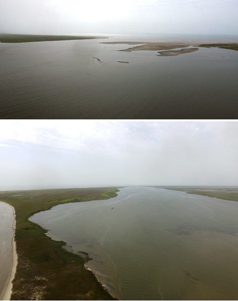
Figure 2. Top: Cavallo Pass, viewed from Matagorda Bay and looking southeast, with the Matagorda Peninsula on the left.
Bottom: Cavallo Pass and the east end of Matagorda Island, looking southwest. The large peninsula on the left side of the photo did not exist before the 1970s. This section of the pass is now closed at its south end.
Cavallo Pass, often referred to as Pass Cavallo, is the large inlet between the Matagorda Peninsula and Matagorda Island. It is the main natural inlet from the Gulf of Mexico into Matagorda Bay, Espiritu Santo Bay, and San Antonio Bay, and is the natural outlet for the Colorado, Guadalupe, and San Antonio Rivers, as well as all of the creeks and other streams in the vicinity. It was originally called "Paso Caballo," or "Horse Pass."
Cavallo Pass used to be much deeper and wider than it is today. Several factors have contributed to its reduction. In the 1930s, the Colorado River delta grew across Matagorda Bay, separating East Matagorda Bay from the rest of the bay system and removing its water volume from the amount that flowed through the pass with the daily tides. A manmade ship channel cut across the Matagorda Peninsula in 1966 further reduced the amount of water moving through Cavallo Pass. As a result, sand and mud deposits have filled in the pass substantially, causing Matagorda Island and the Matagorda Peninsula to grow towards each other and reducing the depth of the pass.
Four parties of the Narváez Expedition crossed Cavallo Pass. The first group included the survivors that arrived in Texas on Governor Pánfilo de Narváez's boat and those from Comptroller Alonso Enríquez's boat who became shipwrecked at the San Bernard River. (For more information about the boats, see our article, "Tracking the Narváez Expedition's Five Boats on the Gulf Coast.") Narváez found Enríquez and his men walking along the coast of the Matagorda Peninsula and used his boat to carry both groups of survivors - about 80 men in total - across the pass. This probably occurred around November 12, 1528. They were followed closely by a group of four Europeans who were shipwrecked on Follet's Island in Brazoria County on November 5 and 6 and who had walked down the coast with a native guide. These men were perhaps only two days behind the large group. Another party of Follet's Island castaways crossed Cavallo Pass the following spring, around April 10, 1529. This group, which consisted of nine men led by Captain Andrés Dorantes, got across using a discarded canoe. Finally, Alvar Nuñez Cabeza de Vaca and Lope de Oviedo, the last two stragglers from Follet's Island, were ferried across the pass by natives in the spring of 1533.
The expedition chronicles refer to Cavallo Pass by the name "Espíritu Santo," or "Holy Spirit." This was a reference to a location on the Gulf that was discovered and named by Spanish explorer Alonso de Pineda in 1519. For our in-depth analysis of Cavallo Pass and the parties of the Narváez Expedition who crossed it, see the article, "Identifying the Inlet of Espíritu Santo".
Matagorda Island is a large barrier island on the Texas Gulf coast. It is approximately 36 miles long and about 2 miles wide. All of Matagorda Island is in Calhoun County. Its neighbor to the east, on the other side of Cavallo Pass, in Matagorda County, is the Matagorda Peninsula. Its neighbor to the west, in Aransas County, across Cedar Bayou, is St. Joseph Island. The bay separating Matagorda Island from the mainland is called Espiritu Santo Bay - a name that the Spanish attached at various times to other bodies of water in the Matagorda Bay area.
The east and west ends of Matagorda Island, while part of the same landmass, have less history in common than one might think. This is especially true when examining the travels and whereabouts of the Narváez Expedition survivors. For that reason, they are discussed in separate sections below.
East End
As with Cavallo Pass, the east end of Matagorda Island has undergone substantial geographical transformation in recent centuries. Today, a chain of islands and islets stretches across the east end of Espiritu Santo Bay from Cavallo Pass to the town of Port O'Connor on the mainland. None of these islands are very substantial, but are marshes that are filled with ponds and channels. Rough maps from the early 1800s, on the other hand, depict east Matagorda Island as an entirely solid landmass that was either fully connected to the mainland or separated from it by one bayou. In the mid-to-late 1800s, the east end of Matagorda Island was substantial enough to support a town, a Confederate fort, and a U.S. Coast Guard station. Detailed maps from the late 1800s do not show as large and solid of a landmass as the earlier maps did, but they do show an area that was decidedly higher and drier than it is now.
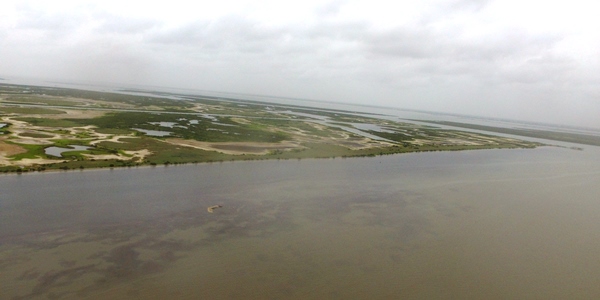
Figure 3. The site of Saluria on Matagorda Island. This may be where Narváez's party made camp the night he was lost.
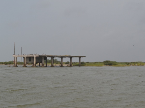
Figure 4. The U.S. Coast Guard had this station at Saluria from 1879 to 1942.
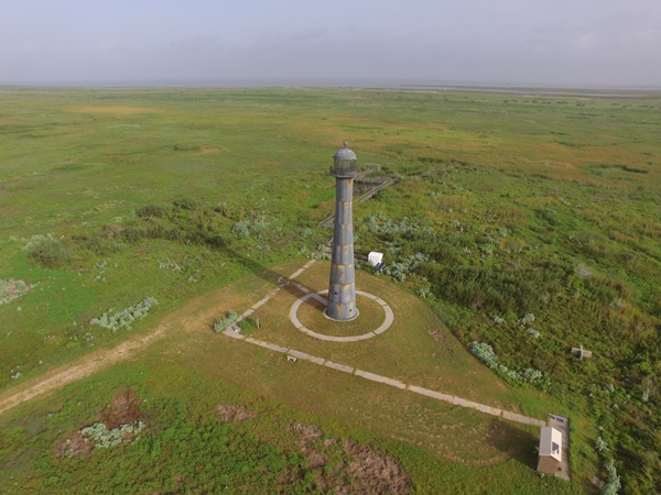
Figure 5. The Matagorda Island Lighthouse, at the east end of Matagorda Island. Cavallo Pass can be seen on the horizon.
The Narváez Expedition
The Narváez Expedition chronicles state that the first group of survivors to arrive on Matagorda Island, the party of about 80 men commanded by Governor Narváez and Comptroller Enríquez, spent the night there after crossing Cavallo Pass by making multiple trips in Narváez's boat. Narváez then did two things that are not explained. First, he announced that the man who had been the second-in-command on his boat, Captain Pantoja, was his new "lieutenant," or second-in-command of the entire party, rather than Enríquez,1 who was rightfully next in the chain of command. Second, rather than going on land that night, Narváez stayed in his boat. With him in the boat were two men: a pilot named Anton Pérez and a page named Campo. In his account of the expedition, entitled La Relación, Cabeza de Vaca writes that the page was ill, but the other account, the Joint Report, edited by Gonzalo de Oviedo, states that all three of the men were. There was no food or water on the boat, and only a rock for an anchor. A strong north wind blew that night, and the next morning, the boat and the three men were gone. Neither they nor their boat were ever found. As the Joint Report states, "One must conclude that the sea swallowed them up."2
The two accounts of the expedition describe what happened next a little differently. Cabeza de Vaca's account is more detailed. It states:
Seeing this, the people who remained on land went along the coast. As they found themselves so greatly impeded by water, they made rafts with much difficulty, and passed in them to the other side.3
The statement that the survivors "went along the coast" but "found themselves...impeded by water" invites some examination. One might think that their plan would have been to continue their journey to Pánuco by walking along the outer coast, that is, the southern edge of Matagorda Island. If they had done this, however, they would not have been impeded by water until they reached the west end of Matagorda Island some four days later. Therefore, they must have gone a different direction. Perhaps they had become weary of walking down the outer coast, where there was little food, water, or firewood. Perhaps they thought that since they no longer had a boat, they could not take the chance of getting stuck on another long peninsula, like Enríquez and his men were the previous day. There were also some in the party who believed that they had already passed Pánuco and needed to turn around.4 Whatever the reason, it appears that the survivors decided to walk northward along the east end of Matagorda Island. As discussed earlier, this area is now barely above water and is filled with marshes and channels. It was higher in the 1800s, but that does not mean that it was smooth and easy to cross in the 1500s. The party went through the trouble of building rafts and crossed "to the other side," that is, the mainland. The date was probably close to November 13, 1528.
The Joint Report simply states that this group "scattered among certain lagoons and swamps which were there and inland." While this short statement does not seem to contain much information, it corroborates the theory that the survivors passed over to the mainland. First, it specifically says they went "inland." Also, the phrase "lagoons and swamps" echoes language the Joint Report uses in describing the Follet's Island castaways' winter home in mainland Brazoria County.
The four swimmers and their native guide crossed Cavallo Pass soon after Narváez's party did. Neither of the expedition chronicles describe their crossing or explain how they managed it, but if they truly were "very good swimmers," as Cabeza de Vaca states, they could have swum across. This group had undoubtedly seen many signs of the large group marching just days ahead of them. On the east end of Matagorda Island, however, their paths diverged, for the swimmers did continue walking southwest down Matagorda Island - presumably, but not necessarily, along the outer coast.
Andrés Dorantes's party of nine crossed Cavallo Pass on or around April 9, 1529. They also continued walking down the coast. They were weak from hunger, having had to subsist solely on grass. Since humans cannot digest most grasses very well, this diet, rather than providing nourishment, made them, as the Joint Report describes, "bloated"5 with gas.
Cabeza de Vaca and Lope de Oviedo caught a ride across Cavallo Pass in early 1533 with a tribe of natives called the Deaguanes.6 Neither La Relación nor the Joint Report explain where on the west side of the pass they landed, but in both texts, all of Cabeza de Vaca's sojourn following this moment takes place on the mainland. The most logical conclusion is that the Deaguanes took Cabeza de Vaca and Oviedo across from the Matagorda Peninsula to mainland Calhoun County, probably around present-day Port O'Connor, and these two Spaniards did not set foot on Matagorda Island.

Order your copy of
The Account of Cabeza de Vaca: A Literal Translation with Analysis and Commentary, translated by David Carson of TexasCounties.net, available in E-book and paperback formats.
Recent History
The first settlers came to the east end of Matagorda Island after the Texas Revolution. In 1847, the town of Saluria was established. It received a post office in 1848. The Confederate army built a fort named Fort Esperanza near Saluria in 1862 to keep Union ships out of Matagorda Bay. The civilian population retreated from heavy Union bombardment during the war. After the war, the fort was abandoned, and attempts to rebuild Saluria were thwarted by a series of hurricanes, so the town never came back. The U.S. government built a Coast Guard station at the old townsite of Saluria in 1879.
Between the Civil War and World War II, all of Matagorda Island was ranchland that belonged mostly to descendants of the original settlers. In 1940, however, the U.S. government condemned and seized the eastern two-thirds of Matagorda Island for use as a bombing range for military training. The Coast Guard base at Saluria closed in 1942. The airfield was closed in 1945.
After the war, the United States returned the Matagorda Peninsula, which was also seized for wartime needs, to its previous owners, but to the consternation of the former owners of east Matagorda Island, the government kept what had been their family property. The old air base was refurbished, and it served as an Air Force base from 1949 to 1975. After the Air Force left, the island was converted to state and federal wildlife preserves. It is accessible only by water or air, and since 2003, there has been no public ferry. The state park facilities, which are normally not staffed, are at the old airfield. Visitors can go there via private or chartered boats for hunting, fishing, hiking, bicycling, and primitive camping. The airstrips and runways are still in place and can easily be seen on satellite photos.
A lighthouse on east Matagorda Island has survived all of these changes in land ownership and use. The original 55-foot-tall cast iron lighthouse was completed at Saluria in 1852, possibly very close to the spot where Narváez's men camped the night he was lost at sea. Because of beach erosion, it was moved to higher ground a few years later. In 1857, an additional 24 feet were added to the tower. During the Civil War, the Confederate Navy attempted to blow up the lighthouse to keep it out of Union hands, but it they only damaged it. It was disassembled and rebuilt at its present location in 1873. It has been renovated several times since then. It is now operated by the Texas Parks and Wildlife Department.
West End
The Narváez Expedition
As the above section explains, only two of the four parties of the Narváez Expedition that crossed Cavallo Pass into Calhoun County walked down the coast of Matagorda Island to its west end. The first party to do so was the group of four strong swimmers who left Follet's Island earlier in November, with a native from that area serving as a guide. The texts do not give any information about this group's journey along the coast, but they do tell us that at least two of the men - and perhaps all five - reached the west end of Matagorda Island. By our calculations, the earliest date the group could have arrived there is November 16, 1528. This would require them to leave San Luis Pass at the east end of Follet's Island on November 11 and travel at a pace of about 21 miles per day for six days straight. This speed is optimistic, but possible, for men who were selected for the journey because they were in good shape and could swim well. If they left Follet's Island later than November 11 or did not travel that quickly, their arrival date would have been after November 16.
The other group that traveled down Matagorda Island was the party led by Andrés Dorantes. Dorantes and the eight other men in his group crossed Cavallo Pass on or around April 9, 1529. The Joint Report describes the next segment of their journey as follows:
The Christians continued their journey weak from hunger, and most of them were bloated from the grasses which they were eating. With much difficulty, these Spaniards arrived at a small bay [ancón] which was twelve leagues farther on. The bay was narrow in width such that its breadth was no more than a river. In this place they stopped the day which they arrived. On the following day they saw an Indian on the other side of the river ... He then left, but he returned again that afternoon. He brought with him a Christian whose name was Figueroa.7
Order your copy of
Children of the Sun: Following in the Footsteps of Narváez and Cabeza de Vaca, by David Carson of TexasCounties.net, available in E-book and paperback formats.
This meeting with Figueroa and the native occurred twelve leagues from Dorantes's party's last reported location, which was the large inlet that can be confidently identified as Cavallo Pass. Twelve Spanish common leagues is about 42 miles. The coastline of Matagorda Island is 34 miles long, which converts to 10 common leagues. At the west end of Matagorda Island is Cedar Bayou, a small natural pass that separates Matagorda Island from the next landmass along the coast, St. Joseph Island (or San Jose Island) in Aransas County. Cedar Bayou is not large. In what is probably no surprise to readers of these articles, this pass has filled in and reopened numerous times. Just in recent times, it closed in the 1970s, then again in the 1990s. It was reopened between 2001 and 2005, but by 2008 it had closed again. It was most recently dredged and reopened in September 2014.
Thiessen's translation of the Joint Report, regrettably, translates the Spanish word ancón as "bay" everywhere it is found. A better translation for ancón would be "inlet," rather than "bay," whose Spanish counterpart is bahía. The text's description of this inlet as "small" and "narrow in width such that its breadth was no more than a river" definitely applies to Cedar Bayou. There is a discrepancy of ten leagues versus twelve from Cavallo Pass, but this is a minor issue. The next inlet, Aransas Pass, is another 20 miles, or 6 leagues, down the coast, making it 16 leagues from Cavallo Pass. Twelve is a lot closer to 10 than to 16. Obviously, the Cedar Bayou pass was open at this time, and must have even been a little wider than it is now, because, like a river, it was big enough to be noted and too large to be crossed easily.
As the chronicles explain, the Christian named Figueroa that the native brought with him was one of the four strong swimmers from Follet's Island. The native brought Figueroa over from the other side of Cedar Bayou - that is, from St. Joseph Island - to speak with Dorantes's party. The only thing the Joint Report adds here is that two of the swimmers had died of hunger by that time, while another was killed by natives. Cabeza de Vaca's La Relación provides more information:
[Figueroa] related for them there how he and his companions had come to that place, where two of them and an Indian had died - all three of cold and hunger, because they had come and stayed in the worst weather in the world. He told them that the Indians had taken him and Méndez.8
While Cabeza de Vaca's wording is a little inexact, we are given to believe that two of the strong swimmers - whose names were Álvaro Fernández and Astudillo9 - plus their anonymous native guide died at "that place," or the west end of Matagorda Island, at Cedar Bayou. While this could be reading the text a little too literally, it does seem safe to conclude that they died somewhere on Matagorda Island, either at the west end or while making the walk there from Cavallo Pass. Figueroa and Méndez became slaves of natives who apparently lived on St. Joseph Island. These natives subsequently killed Méndez when he tried to escape. This would mean that Figueroa and Méndez made it across Cedar Bayou into Aransas County before being captured, but Fernández, Astudillo, and their guide were already dead by that time.
Cabeza de Vaca's comment that the swimmers "came in the worst weather in the world," causing Fernández, Astudillo, and the guide to die "of cold and hunger" helps to corroborate our estimate of the timing of their journey. Elsewhere, he writes that "a few days after these Christians left" Follet's Island, the weather there turned "cold and stormy."10 This began a winter season in which the food supplies stopped and dozens of Europeans died of cold, hunger, and illness, causing the survivors to name that place the Isla de Malhado, or "Island of Misfortune." Clearly, this seasonal change that commenced "a few days" after the swimmers left Follet's Island was the same one that had them caught "in the worst weather in the world" on Matagorda Island. This fits our theory that the swimmers were on Matagorda Island within three days of leaving Follet's Island and were all the way to Cedar Bayou - and down to two men - by the end of their sixth day of travel.
Before this meeting with Dorantes and his men, Figueroa had been able to speak with a castaway named Hernando de Esquivel, who had been a member of the Narváez-Enríquez party that crossed Cavallo Pass a couple of days before the four swimmers and then went over onto the mainland. Through Figueroa, Dorantes and his party found out what had happened to Governor Narváez and the rest of his party.
After Figueroa spoke with Dorantes's group for a while, the native keeping him was ready to go. Figueroa had to go with him, but the native said he was willing to give the others some fish. Exactly what was communicated to the Europeans is uncertain, but evidently either the native and Figueroa swam across Cedar Bayou for this meeting, or their canoe was too small to carry the whole group, because two of the famished Europeans - the only ones out of the group who could swim - went with them, while the other seven remained on Matagorda Island. One of the two was a holy man from Asturias, Spain. The other was a "young boy" whose name was not given. The boy returned the next morning with a small amount of fish. The party, now numbering eight, camped another night on the west end of Matagorda Island "due to the many needs which they had." The next morning, they caught a ride across Cedar Bayou with some other natives.
As explained in our article, "The Narváez Expedition in Matagorda County," the Joint Report tells us that Dorantes and his party traveled down the Matagorda Peninsula in Matagorda County at the rate of between 12½ and 17 miles per day for four days. At that same pace, it would have taken this group two days plus part of a third day to walk from Cavallo Pass to Cedar Bayou. If they crossed Cavallo Pass on April 9, 1529, as we estimate, then they reached Cedar Bayou on April 11 or April 12. For the purposes of this exercise, we will use the later date. This would mean that they met with Figueroa on April 13, the boy returned with the fish on April 14, and the group - now missing the Asturian and down to eight - left Matagorda Island on April 15, two weeks after leaving the Island of Misfortune.
Recent History
Unlike the east end of Matagorda Island, which was the site of a town and some military installations in the 1800s, the west end of the island remained unsettled and undeveloped and was only used for cattle ranching. In the 1930s, Dallas oil tycoon Clint Murchison Sr. began buying ranches with mineral rights on the west end of the island for his company, American Liberty Oil. All of the oil company's drilling sites came up dry, but Murchison continued to raise cattle and built an elaborate retreat for family and friends.
Murchison and his friend and fellow oilman, Sid Richardson, who owned neighboring St. Joseph Island and built his own retreat on it, became friends with President Franklin D. Roosevelt's son, Elliott. In May 1937, Franklin and Elliott Roosevelt enjoyed a week-long fishing vacation on Richardson and Murchison's estates. In 1938, Toddie Lee Wynne Sr. became Murchison's equal partner in American Liberty Oil. When the U.S. government condemned and seized most of Matagorda Island to use as an air base in 1940, the west end of the island was not taken. The seizure line was drawn along the fence of the wealthy and politically-connected oilmen's 8,000-acre ranch. Murchison and Wynne divided their interests in 1946, with Wynne receiving the Matagorda Island ranch in a coin flip. After Wynne bought another 3,000 acres, he owned a contiguous 11,502 acres, or 18 square miles, on the west end of Matagorda Island.
After Wynne's death, ownership of west Matagorda Island passed to his son, Toddie Lee Wynne Jr. In the early 1980s, Wynne invested in Space Services Inc., a private space company, and his ranch was used as the site of their first test launch, which failed with an explosion. Wynne sold his interest in Matagorda Island in 1986 and died the following year. The former Murchison-Wynne ranch is now part of the Aransas National Wildlife Refuge.
The mainland of Calhoun County is on the north side of Espiritu Santo Bay, opposite Matagorda Island. It is bounded by San Antonio Bay and the Guadalupe River on the west and Matagorda Bay on the east. Calhoun County extends about 25 miles inland. We know that many of the Narváez Expedition survivors lived here for a while. Unfortunately, many of them also died here.
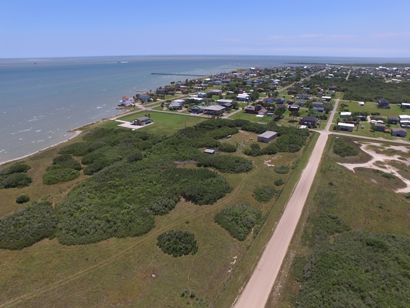
Figure 6. Aerial view of Port O'Connor looking southwest into Matagorda Bay.
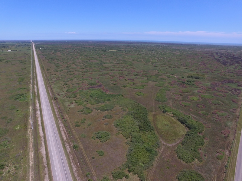
Figure 7. Aerial view of Highway 185 through south Calhoun County, looking east.
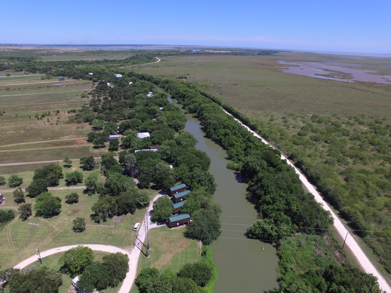
Figure 8. This view of the Guadalupe River, on the Aransas-Calhoun County line, looks south approximately from Highway 35. Tall, lush trees are thick along the river banks, but scarce everywhere else.
The Narváez Expedition
The first survivors to come here were those in the large group who had come to Texas on Governor Narváez and Comptroller Enríquez's boats. On about November 13, 1528, they crossed over from the east end of Matagorda Island, having just lost Narváez, two other men, and their last boat in an accident. Cabeza de Vaca writes:
Going further, they came to a point of a forest at the edge of the water, and they found Indians, who, when they saw them, put their dwellings into their canoes and passed over to the other part of the coast. The Christians, in view of the season, because it was the month of November, stopped to stay in these woods, because they found water, firewood, some crawfish, and seafood, yet they began to die little by little of cold and hunger.11
"A point of forest" implies a patch of woods in an area that is otherwise not wooded. Clumps of trees such as that usually indicate the presence of groundwater, such as a creek. The note that their stopping point was "at the edge of the water" implies that they were near a saltwater bay. Put together, it appears that the castaways were at the mouth of a creek on one of the bays surrounding the mainland. The presence of crawfish, which live in muddy lowlands or swamps, corroborates this hypothesis.
Neither of the texts tell us exactly where we ought to look for this site. We assume that the Pantoja-Enríquez party crossed over from Matagorda Island to "the other side" somewhere around present-day Port O'Connor, but what does "going further" mean? How far, and in what direction did they go? We have insufficient information to even make an educated guess. There are several creeks on the Calhoun County mainland that empty into Matagorda Bay, Espiritu Santo Bay, or San Antonio Bay, but there is not a noticeable "point of woods" on any of them today. It is possible that our interpretation is wrong, but it is at least equally possible that 200 years of human settlement and 500 years of natural processes have changed the land. As Figure 6 shows, there are some woodsy locations north of Port O'Connor today, but the simple existence of some clumps of trees is not enough to be persuasive that we have found the site.
Despite their access to firewood and food, the castaways started dying from cold and hunger. As explained in the previous section, Cabeza de Vaca elsewhere mentions the arrival of bad, cold weather both on Follet's Island and Matagorda Island. This change in the seasons probably occurred around November 14 to November 16. In relating what happened to this group on the mainland, he tells a miserable story in which a man named Sotomayor killed the group's leader, Pantoja, over his poor treatment of the castaways and the survivors "made jerky out of" those who died and ate them. Only one man out of this group survived the winter.
If we assume that this party had 80 men when it crossed Cavallo Pass12 and we subtract the three men who disappeared on east Matagorda Island, then 77 Europeans came over to the mainland in November 1528, and 76 of those died. The roll call of the dead includes Pantoja, Alonso de Sotomayor - who Cabeza de Vaca identifies only by his last name, but whose full name is known via other historical records - and Comptroller Alonso Enríquez. The names of the other 73 dead men cannot be known. They could possibly include Juan Suárez and Juan de Palos, two of the expedition's five friars. Suárez, the "commissary" or head friar, was designated as co-leader of Enríquez's boat when the boats left Florida, but neither he nor de Palos are mentioned again after the boats leave Florida, so Suárez may not have survived the trip to Texas, while de Palos may not have even made it out of Florida. Cabeza de Vaca only tells us that Enríquez had "the friars" with him on his boat.
Around the first day of March 1529, the natives who left the woods upon the arrival of Pantoja's party returned. They found the lone survivor of this group, Hernando de Esquivel, and took him captive.13 The natives that found and captured Esquivel were with the tribe that Cabeza de Vaca identified as Quevenes.14 According to Cabeza de Vaca's list of the "nations and languages" of the natives in Chapter 26 of La Relación, the Quevenes lived down the coast from the Deaguanes, up the coast from the Guaycones, and adjacent to the Mariames, who lived inland.15 While Cabeza de Vaca's description of the Quevenes as living "on the coast" may seem to imply that they lived on Matagorda Island, all of the castaways' recorded interactions with them appear, as in this instance, to have occurred on the coastal part of mainland Calhoun County. Esquivel did not stay with the Quevenes very long; within a month of them finding him, he fled inland to the Mariames.16
Some time after Esquivel was captured around March 1 and before Dorantes's group's arrived at the west end of Matagorda Island around April 12, Esquivel and Figueroa had a chance to meet and talk. This meeting was the means by which Figueroa was subsequently able to relate to Dorantes's group what had happened to Narváez and the people with him. All we know about how this meeting came about is that Figueroa was living on "the coast" at the time, he came to see Esquivel, and Esquivel was still in the natives' "custody."17 When the two Spaniards were together, Figueroa told Esquivel they should make a break together and try to go to Pánuco. Esquivel, however, was one of those who believed that they had already passed Pánuco and should go back up the coast. Figueroa, who had just walked over a hundred miles down the coast, knew differently, but Esquivel would not be convinced, so they separated when the natives keeping them went back to their respective territories. Figueroa told Dorantes's party that Esquivel had fled from the Quevenes to go live with the Mariames,18 and if they spent some time in that area, they might be able to find him.19
Dorantes's party was on the west end of Matagorda Island when they learned about Esquivel. As weak and hungry as they were, they had no intention of backtracking, and moved ahead to St. Joseph Island. As fate would have it, however, Andrés Dorantes did eventually wind up in Mariame territory. In the middle of August 1530, he went there by himself to escape the harsh treatment he had endured at the hands of some other natives.20 Whether or not he improved his lot is debatable. When he arrived, the Mariames informed him that they had killed Esquivel over a woman's dream. They showed him Esquivel's sword, rosary, and other personal belongings.21 This happened within a month after Esquivel arrived,22 or around April or May 1529.
The last two members of the expedition to arrive in Calhoun County were Cabeza de Vaca and Lope de Oviedo. In early 1533, perhaps March, they were taken across Cavallo Pass by the Deaguanes. Cabeza de Vaca writes that "on the other side" of the pass, "we saw some Indians, who came to meet those who were with us."23 He identifies them as the Quevenes, the tribe that had found Esquivel about four years earlier. The Deaguanes had recently been at war with them, but they had negotiated a treaty.24. The Quevenes "told us how further on, there were three men like us, and they told us their names." They also told them about some of the Spaniards who had died, including five who other natives had killed. The Quevenes beat Cabeza de Vaca and Oviedo and treated them roughly, telling them that the Christians ahead of them had it much worse. This was too much for Oviedo, who decided to go back with the Deaguanes, leaving Cabeza de Vaca alone. Oviedo is never mentioned again; we are left to assume that he went back to Matagorda County with the Deaguanes.
The Joint Report's account of this incident is similar, but it adds that it occurred "ten leagues onwards" after Cabeza de Vaca and Oviedo crossed "this previously mentioned bay of Espíritu Santo,"25 or Cavallo Pass. Ten leagues equals 35 miles. The mainland of Calhoun County west of Cavallo Pass is less than 20 miles wide. In order to travel 35 miles - though this is surely only an estimate - they would have had to walk substantially far inland, not just straight down the coast. Supposing that the Deaguanes landed near Port O'Connor, they must have walked west to northwest with the intention of going around the north end of San Antonio Bay. Today, Texas Highway 185 goes from Port O'Connor to Seadrift to Highway 35 along a route that may well be similar to the one Cabeza de Vaca and Oviedo traveled in 1533.
Both La Relación and the Joint Report explain that the area Cabeza de Vaca found himself in was one where several tribes came annually to eat nuts. Cabeza de Vaca's account reads:
... to eat those nuts [nueces] on which they subsist, grinding some grains with them, two months of the year, without eating another thing. Even at that, they do not have them every year, because they grow one and not another. They are the size of those of Galicia, and the trees are very large, and there are a large number of them.26
Many translations of La Relación and the Joint Report translate nueces here as "walnuts," a nut species that is common in Spain and is probably the variety Cabeza de Vaca meant by "those of Galicia." Walnuts were introduced into the Americas by Spaniards, however; the nuts the natives ate had to have been a native species. Most researchers agree that these nuts were pecans. Pecan trees are native to Texas and thrive in areas that are well-watered, have good drainage, and experience mild winters. They can grow to about 70 feet high. Their crop production from one year to the next can vary widely depending on the weather and other conditions.
It is worth examining the Joint Report's version of this passage:
There are many walnuts along the banks of that river, and the Indians eat them in their season. These walnut trees in that place bear nuts one year, and they do not another. Sometimes, a year or two passes when there is no crop. However, when they are there, those nuts are many. At this time, the Indians gather from twenty or thirty leagues around that place, as they are extremely fond of eating them. These natives suffer great necessity, because there are so many people who come for these walnuts ... The crop lasts for an entire month, and they eat nothing else during this time. These nuts are much smaller than those of Spain, and it is very difficult to get out what is inside, so that it can be eaten.27
Notwithstanding the disagreement over whether pecans are "the size of" walnuts or "much smaller" than them - they are actually a little smaller, but not much - this passage adds that the trees are on a river bank. It also implies that there was one tribe who lived on this river of nuts more or less permanently, and for the month or two that the nuts were in season, other tribes came in from outside the area, causing the regular residents "great necessity."
While Cabeza de Vaca was with the Quevenes, and only two days after Oviedo left, Cabeza de Vaca, on the advice of a native from another tribe, snuck away from the Quevenes and found Dorantes in the nut groves. He was still a captive of the Mariames. Dorantes reunited him with the two other Europeans, Alonso del Castillo and Estevanico, who were slaves of the Iguaces. Cabeza de Vaca wanted all of them to leave together, but the others advised him that it would be much better to wait until the natives went on their annual migration to the cactus fields of south Texas. "With this decided," Cabeza de Vaca writes, "I stayed there," that is, with Dorantes and the Mariames. This statement indicates that these Mariames were the regular inhabitants of the "river of nuts," while "their neighbors, called Iguaces," who had Castillo and Estevanico, were one of the tribes who sometimes visited the area. It would appear that the Mariames' camp was not far from where Cabeza de Vaca and Lope de Oviedo met the Quevenes.
Historians almost uniformly take this "river of nuts" to be the Guadalupe River, which forms the western boundary of Calhoun County. Krieger writes, "It is likely ... that the pecan groves they visited were along the lower reaches of the San Antonio and Guadalupe Rivers." The San Antonio River pours into the Guadalupe about seven miles above San Antonio Bay. The area between these two rivers is in Victoria County. The Joint Report alludes to that area when it states, "they hunt mice between those rivers." Even if we cannot be sure that "between those rivers" means the between the San Antonio and the Guadalupe, it is safe to assume that if the river of nuts was the Guadalupe, the castaways visited both sides of it at some time during their years in the area. Furthermore, Calhoun County ends and Victoria County begins on the east bank of the Guadalupe River about six miles above the mouth of the San Antonio River. Therefore, we assume that Cabeza de Vaca, Dorantes, Castillo, and Estevanico spent part of their time as captives of the Mariames and Iguaces in Victoria County.
As demonstrated above, we can establish with a high degree of confidence through textual analysis that Cabeza de Vaca met Dorantes and the Mariames in northwest Calhoun County near the Guadalupe River. There is a glaring problem in the texts, however, relating to the month of Cabeza de Vaca's arrival. Pecans, as well as most other kinds of tree nuts, are harvested in the late autumn, but Cabeza de Vaca writes in three places that he had to wait six months after his arrival for the natives to migrate to the south Texas cactus fields. This migration was from about July through September. The nut harvest would have begun soon afterward and would have lasted through about November. If Cabeza de Vaca arrived to meet Dorantes during the annual nut harvest, as both of the texts state, he would have come in late 1532, nine to eleven months before his first chance to escape in the cactus fields, not six months. This would also throw off other elements of the timeline, such as the Joint Report's statement, "It had been five years, since they had left him behind where they had lost the boats."28 The only way to preserve the timeline established by the expedition chronicles is to place Cabeza de Vaca's reunion with Dorantes in early 1533 - possibly March, since it would be unlikely for him and Oviedo to begin a cross-country journey in the winter. It is certainly possible that the Iguaces sometimes migrated to the Guadalupe River area for reasons other than gathering pecans and that the writers of the chronicles misremembered the occasion of this meeting.
The Mariames and Iguaces did go to south Texas later in 1533 as anticipated, but the four castaways were unable to escape. Cabeza de Vaca and Dorantes returned to Calhoun County for another year. Presumably, the Iguaces visited the area with Castillo and Estevanico on one or more occasions during the year as well.
The castaways did successfully escape from the Mariames and Iguaces in south Texas the following year, so their final departure from Calhoun and Victoria Counties would have been when their hosts began that trip. This would have been in the summer or early autumn of 1534, perhaps July.
Recent History
The Narváez Expedition made Spain aware of Matagorda Bay, but no European returned there until Robert La Salle arrived in 1685 and established his short-lived French colony in Victoria County. The Spanish explorer, Alonso de León, came in 1689 to find the destroyed remains of La Salle's colony.
Present-day Calhoun County was part of Martín de León's empresarial grant, which he obtained in 1825. The first settlement was Linnville, established near the present site of Port Lavaca. Calhoun County was created in 1846.
Port O'Connor, where many of the Narváez Expedition castaways may have crossed over from Matagorda Island, was founded in 1909. This unincorporated community of about 1,200 is primarily a fishing, leisure, and retirement destination today.
The southern section of mainland Calhoun County, where the Quevenes lived and which Cabeza de Vaca and Lope de Oviedo probably walked through, is mostly undeveloped ranchland. The flat, clay soil is poorly drained and has a high salt content, making it unsuitable for grasses or crops. As Figure 7 shows, its surface consists of dirt, salt-tolerant shrubs, and standing water.
The lower segment of the Guadalupe River, which was probably the home of the Mariames and a seasonal feeding ground for other tribes, is low-lying and not suitable for wide-scale development, so this is a rural area with no towns. There is a string of houses on raised piers on the east bank of the river, in the shade of the pecan and other large hardwood varieties that still grow there.
| County | Castaways Who Visited | Dates | Castaways Who Died |
| Calhoun | Four parties including about 95 people | From Nov. 12, 1528 to April or May 1529, then August 1530 to July 1534 | Álvaro Fernández, Astudillo - "of cold and hunger"
Governor Pánfilo de Narváez, Anton Pérez (Narváez's pilot), and Campo (Narváez's page) - lost at sea
Pantoja (officer) - in a quarrel with Sotomayor
Alonso Enríquez (comptroller or "the accountant"), Alonso de Sotomayor (chief of staff), and about 74 others - "of cold and hunger"
Hernando de Esquivel - killed by the Mariames |
| Victoria | Cabeza de Vaca, Dorantes, Castillo, and Estevanico | From August 1530 to July 1534 | None |
By David Carson
Page last updated: December 15, 2017
