
El Camino Real de los Tejas
Introduction
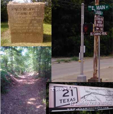
El Camino Real de los Tejas, or "The royal road of the Tejas," was a major overland route across Texas. Originally used in the late 1600s to connect the Spanish missions among the Hasinai ("Tejas") and other tribes in east Texas to the government centers in Mexico, this "royal road" or "king's highway" stretched about 600 miles from the Rio Grande through San Antonio and Nacogdoches to the Sabine River, continuing into Louisiana and terminating at Natchitoches. In time, the missions were phased out, but El Camino Real's route shaped the placement of Texas' population centers and served as a vital link between them and the central government. In the early 1800s, thousands of colonists from the United States arrived via the Camino Real. Today, parts of it have been erased, but other parts are still very much in use as modern highways.
List of Articles
- Origins of El Camino Real de los Tejas - The expeditions from 1689 to 1717 that established the road.
- History of El Camino Real de los Tejas - How a mission trail became "the royal road of Texas", and what part each of its principal routes played in Texas history.
- Rediscovering and Preserving El Camino Real - A review of 20th and 21st-century work to preserve the historic roads.
- A Tour of the Old San Antonio Road - Our own county-by-county tour of El Camino Real as it looks today.
- Using Lidar to Map El Camino Real - Lidar technology is used to enhance our understanding of El Camino Real.
Documents
- Field Notes and Detail Map of the Kings Highway by V.N. Zively, 1916 (PDF, 6.5 Mb) - Contains 114 pages of Zively's sketches and field notes "From Pendleton's Ferry on the Sabine River to Paso de Francia on the Rio Grande." Also includes a preface by Zively and a translation of Friar Morfi's 1778 diary.
Note: The above file is a low-resolution copy of a copy. It is the one we used to do our 2013-2015 El Camino Real project, so it should allow you to get the job done in most cases. There is, however, a much better copy available. You can view it page-by-page and download individual pages at the Texas State Library and Archives Commission. Unfortunately, the entire volume is too large for us to make available for public download. If you need it, e-mail the webmaster (get the e-mail address from "About This Site") and maybe you will catch him in a good mood.