
The Old San Antonio Road Posts and Markers in East Dimmit County
The Old San Antonio Road Posts and Markers in East Dimmit County
- Map of the Old San Antonio Road in East Dimmit County
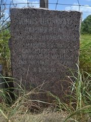
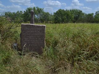
- Marker #115
- Marker #116
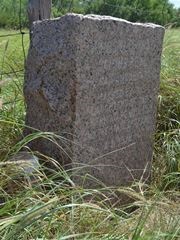
- Marker #117
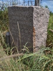
- Marker #118
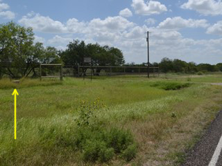
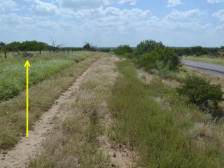
Zively placed ten oak survey posts for the Old San Antonio Road in Dimmit County. Four of them were placed in the southeastern part of the county shown on this map. All four have been moved from their original locations to the sides of modern roads.
Map of the Old San Antonio Road in East Dimmit County
[-]Collapse Map [+]Expand Map
|
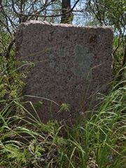
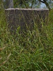
Marker #: 115
Coordinates: 28.294548, -99.395127 Location: FM 133 at the Dimmit-La Salle County Line Relation to Road: 61 feet from south stripe, oriented N 20° Distance from post: 7.3 mi south of post, off route Dimensions: 38" x 27" x 13" Setting: Concrete, trees, weeds Other Markers/Signage: No Visibility: Medium Accessibility: Medium This marker's original location was on the Dimmit County side of the Dimmit-La Salle County line at or near where Cochina Ranch Road/Briscoe Ranch Road intersects it today. It is now over seven miles south of there, on Farm-to-Market Road 133. It is 121 feet west, or on the Dimmit County side, of a sign indicating the county line. It is in front of a tall wire game fence and behind a fire lane. A cluster of mesquite trees around the marker hampers both visibility and accessibility. There is a wide shoulder for parking, and the walk to the marker is not difficult, so it is easy to approach the marker within a few feet of it, but performing a close inspection of it would require cleaning up the mesquites first. The marker's face is splotched with multiple kinds and colors of plant residue. A ground probe indicates the presence of a concrete base underneath the soil. The line that forms the boundary between Dimmit and La Salle County is the same line that separates Frio and Zavala County, as well as Medina and Uvalde County. Long, north-south lines such as this are some of the most difficult county lines to accurately represent on maps. Most local and county maps, and many state maps, depict longitude lines such as these as forming perfectly rectangular counties when, in fact, they are not perfectly rectangular. Dimmit County, as well as every other Texas county that has north-south lines as its boundaries, is actually slightly trapezoidal - wider on the bottom than on the top - because the longitude lines that form their boundaries become further apart from each other as they approach the equator. Consequently, many otherwise high-quality maps produced by both the state of Texas and by third parties show breaks or zig-zags as this line goes from the top of Medina County to the bottom of La Salle County. There should, however, only be one continuous line of longitude. According to the Texas statues that created these counties, this boundary is defined as a north-south line located exactly 36 miles west of the southeast corner of Medina County. This line corresponds to -99.4° longitude, and it is the line used on our map at the top of this page. When compared to the -99.4° longitude line required by Texas statues, the county line signs on FM 133 are 0.3 miles too far east, and OSR Marker #115 is therefore 0.3 miles inside La Salle County. It is unknown when this marker was moved here. FM 133 was designated in 1945, but this section of it already existed as a county road prior to receiving that designation. Observed on July 11, 2015. |
|
|
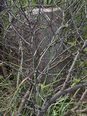
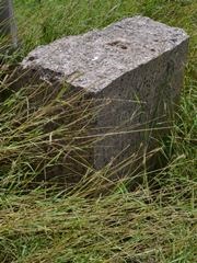
Marker #: 116
Coordinates: 28.311595, -99.465727 Location: FM 133 west of the Dimmit-La Salle County line Relation to Road: 62 ft from south stripe, oriented N 10° Distance from post: 4.6 mi south of post, off route Dimensions: 31" x 27" x 12" Setting: Dirt and grass Other Markers/Signage: No Visibility: Medium Accessibility: Good This marker is on FM 133 on the east side of the entrance to the Piloncillo Ranch and across from the Rancho Encantado. It is 4.4 miles west of OSR Marker #115 and the sign marking the Dimmit-La Salle County line. It is in front of the ranch fence and behind a fire lane. It rests in hard earth. It is surrounded by tall native grass, which reduces visibility. There is a firm grass shoulder on the highway for parking. This marker was originally placed 4.6 miles north of here, at close to the same longitude. Its original location is now open ranchland, far removed from any modern road. The section of FM 133 the marker is now on does not appear on a 1940 Dimmit County road map, so it may have been constructed circa 1945, when FM 133 was opened. The marker was presumably moved here either concurrent with the opening of the highway, or sometime afterward. Observed on July 11, 2015. |
|
|
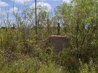
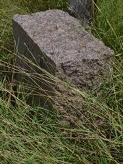
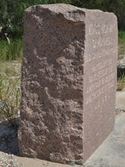
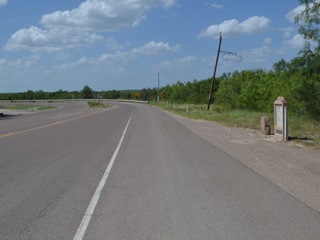
Marker #: 117
Coordinates: 28.331864, -99.564784 Location: FM 133 east of Catarina Relation to Road: 83 feet from south stripe, oriented N 350° Distance from post: 1.7 mi southwest of post, off route Dimensions: 41" x 29" x 20" Setting: Dirt and grass Other Markers/Signage: No Visibility: Low Accessibility: Medium This marker is on FM 133, 3.0 miles east of State Highway 83. It is 1.0 mile west of the entrance to the San Roque Ranch and 0.6 miles east of the east end of the San Roque Creek bridge. It is on the south side of the highway on top of a tall, wide ridge. It is in front of a wire fence and behind a fire lane in a natural grass setting. The marker's elevation relative to the road makes it a little difficult to find. There is a paved pulloff for parking, which may help locate the marker. Accessibility is medium because of the short climb up the ridge. This marker is bigger than average in all three dimensions - height, width, and depth. It has a few rust-colored stains on the sides. There is a cast concrete pillar, 20 inches tall, on the left side of the marker. It has beveled corners and no inscription. The San Roque River flows to the northeast, emptying into the Nueces River. About 3 miles northeast of this marker, the San Roque River is dammed, forming a narrow, string-shaped lake almost a mile long. Zively drew the river and lake on his sketch and showed the Kings Highway crossing the river just below the southern end of the lake. This is where he placed the oak survey post for Marker #117. The section of FM 133 the marker is now on apparently did not exist until FM 133 was opened in 1945, so the marker was presumably moved here at that time, or later. Observed on July 11, 2015. |
|
|
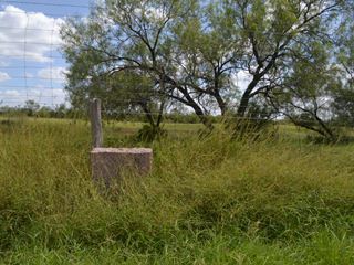
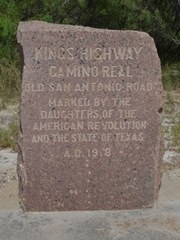
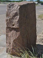
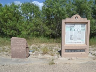
Marker #: 118
Coordinates: 28.351605, -99.613910 Location: Highway 83 in Catarina Relation to Road: 23 feet from east stripe, oriented W 270° Distance from post: 1.2 mi northeast of post, off route Dimensions: 38" x 28" x 14" Setting: Concrete Other Markers/Signage: Yes Visibility: High Accessibility: Excellent This marker is on Highway 83 in Catarina, across the street from, and slightly south of, the historic Palm Hotel. An Old San Antonio Road informational display erected by the state of Texas is next to it. There is a historical marker sign pointing to this area from across the street. The stone is substantially thicker on the left side compared to the right side. Its depth on the left side is 14 inches, while the right side is only 10 inches deep. When the Texas Society Daughters of the American Revolution (DAR) documented this marker in 1995 or later, it was at a different location, on a ranch southwest of Catarina owned by Mr. Merle Burns. The DAR made a photograph of it and noted that it faced east. The DAR's project web site was updated sometime between July and October 2004 to indicate that the marker had been moved to its current location in Catarina. All of the other Old San Antonio Road displays such as the one next to Marker #118 were placed in 1991. We do not know whether this display was installed with the others in 1991 and Marker #118 was subsequently moved next to it, or whether this display was placed later, when the marker was moved. Observed on July 11, 2015. |
|
- Carson, David - field notes observed and recorded in 2015
- Zively, V.N. - "Field Notes and Detail Map of the Kings Highway", 1916
- Texas Society Daughters of the American Revolution - Old San Antonio Road DAR Marker Information Site