
The Old San Antonio Road Posts and Markers in Central Dimmit County
The Old San Antonio Road Posts and Markers in Central Dimmit County
Also see The Old San Antonio Road in Central Dimmit County.Zively placed ten oak survey posts for the Old San Antonio Road in Dimmit County. Three of them were placed in the south central part of the county shown on this map. One has been moved a short distance; another has been moved a little further. Both of those are still on the historic route, albeit on private property. The third marker originally placed in south central Dimmit County has been moved so far west it is now in the southwest part of the county, and is not pictured on this page.
Map of the Old San Antonio Road in Central Dimmit County
[-]Collapse Map [+]Expand Map
|
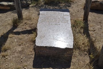
Marker #: 119
Coordinates: 28.31967, -99.7025 Location: Southwest of Catarina Relation to Road: not applicable Distance from post: 0.2 mi east of post, on route Dimensions: Not available Setting: Dirt and brush Other Markers/Signage: No Visibility: N/A Accessibility: N/A This marker is on land southwest of Catarina once known as the San Ysidro Ranch. The entrance to the ranch is on Farm-to-Market Road 2688 approximately 5 miles from US Highway 83. The marker is inside gated private property and is inaccessible to the general public. The Texas Society Daughters of the American Revolution (DAR) documented this marker for their 1995-2001 marker rededication project. They made a photograph of the marker, showing it in the dirt by a mesquite bush in a relatively open area. They noted that it faced west. We were unable to obtain permission to visit the marker in 2015, but we did confirm that it is still at the same site. When we showed the DAR's photograph to some employees familiar with the marker, one of them said that the marker and its setting appear "exactly the same" as in the photo. The marker's location, as described by the people we spoke with, does correspond to the coordinates given by the DAR on their project web site. According to the DAR's notes, "the ranch owner moved it about 300 yards from the original location." Observed on August 8, 2015. |
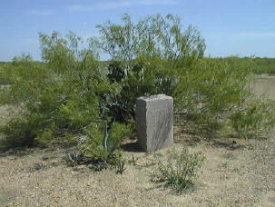 Above: The Texas Society DAR's photograph of Marker #119, made between 1995 and 2001.
|
|
Marker #: 120
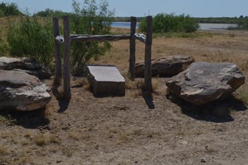
Coordinates: 28.275168, -99.836681 Location: Briscoe Ranch southwest of Catarina Relation to Road: not applicable Distance from post: 3.2 mi southwest of post, on route Dimensions: unavailable Setting: On top of dirt and grass Other Markers/Signage: No Visibility: N/A Accessibility: N/A This marker is on the Briscoe Ranch southwest of Catarina. The entrance to the ranch is at the southwest end of Farm-to-Market Road 2688. The marker is about 1.9 miles northwest of the gate at the end of the road. This is private property and is inaccessible to the general public. The marker is lying on its back on top of the ground, tilted slightly forward. It is inside a small, open structure built of out wooden posts and beams. The structure is surrounded by four large boulders - one at each corner. There is a pond nearby. This marker is more than 3 miles southwest of its surveyed location. An employee at the ranch told us that it was in its current setting when he began working there in 2009. This site was apparently cleared and built not long before then, for satellite images from October 2008 and earlier show the site full of mesquite brush. Whether or not the marker was in this spot back then cannot be determined from the satellite photos, but it was definitely not in the same setting. The marker had never been documented until our visit in August 2015. Satellite images also show a faint trace on the ground marking the path of the Kings Highway as surveyed by Zively in 1915. The marker is a few feet away from this path. Observed on August 8, 2015. |
|
- Carson, David - field notes observed and recorded in 2015
- Zively, V.N. - "Field Notes and Detail Map of the Kings Highway", 1916
- Texas Society Daughters of the American Revolution - Old San Antonio Road DAR Marker Information Site