
The Old San Antonio Road in East Nacogdoches County
The Old San Antonio Road in East Nacogdoches County
- Map of the Old San Antonio Road in East Nacogdoches County
- Route Details
- Chireno
- SH 21 / Melrose / CR 302
The Old San Antonio Road runs through the northern half of Nacogdoches County. East of the city of Nacogdoches are two towns, Melrose and Chireno, that were waypoints for travel between Nacogdoches and San Augustine. The route of the Old San Antonio Road through Nacogdoches, Melrose, and Chireno has been lost, but in between these towns, it is preserved by Highway 21.
Today, this entire area is being used for natural gas production.
Map of the Old San Antonio Road in East Nacogdoches County
[-]Collapse Map [+]Expand Map
Route Details
- State Highway 21 from Attoyac Bayou (the San Augustine-Nacogdoches County line) for 2.0 miles to where it turns from west to southwest, approximately at County Road 395. Highway 21 has an inexact conformance to the OSR for this segment. It has two undivided lanes with no shoulder.
- Route lost from SH 21 approximately at CR 395 for about 2.2 miles to OSR Marker #11 on SH 21. Rather than dipping to the south, as SH 21 does, the OSR went approximately straight across to the northwest.
- SH 21 from OSR Marker #11 for 7.3 miles to Farm-to-Market Road 3276, exact conformance. SH 21 has two undivided lanes with no shoulder.
- SH 21 from FM 3276 for 0.7 miles to CR 302. SH conforms only loosely to the OSR route for this segment.
- From SH 21 at CR 302 to Nacogdoches, Zively's route may be mistaken (see the discussion below). His route falls between SH 21 and CR 302 and is mostly lost, except for a small segment where it coincides with SH 21 between CR 404 and Scott Lane. The known historic route of the Old San Antonio Road is County Road 302 from SH 21 for 8.7 miles to SH 7 in Nacogdoches. CR 302 has one lane. It is paved for most of the route, but a portion of it is dirt.
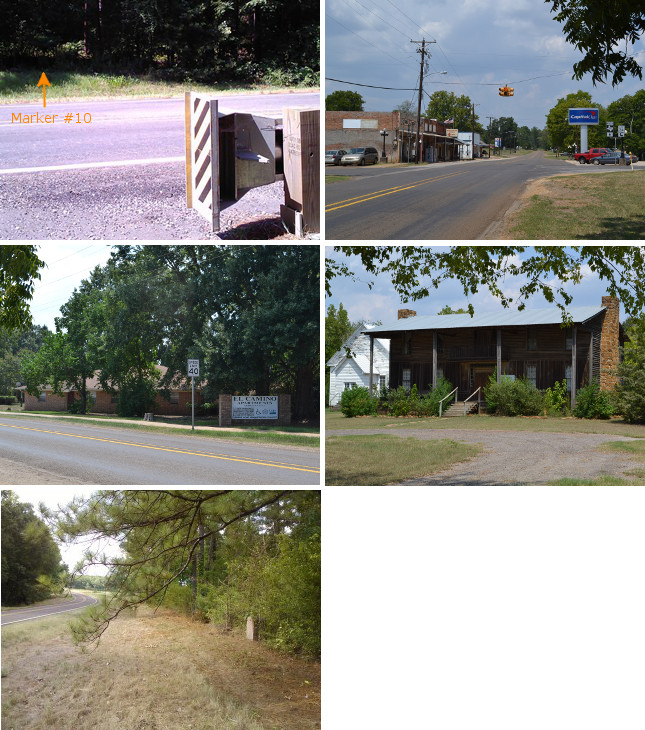
Middle (l to r): El Camino apartments in Chireno; the Flournoy-Granberry House.
Bottom: Site of OSR Marker #11.
Chireno
The Attoyac River is the Nacogdoches-San Augustine County line. The bridge there today goes straight across the river, instead of cutting to the south, as the Old San Antonio Road did. Other than that, Highway 21 follows the Old San Antonio Road west of the river. OSR Marker #10 is tucked away in the shadows and brush on the west bank of the river.
Four miles west of the river is the town of Chireno. Chireno was named after José Antonio Chirino, a Spaniard who received the first land grant there in 1792 and then sold parcels to settlers.
Zively's 1915 survey of the Old San Antonio Road through Chireno shows two routes. The older, northern one, marked "The Kings Highway", was probably the Camino de los Tejas used during the mission period of the 1700s and late 1600s. It shows a location called "Old Fort Chireno", which may have been José Chirino's original settlement. None of this northern route exists today. The southern route, which Zively called the "Road now used", corresponds roughly with present-day Highway 21, and is where the town formed in the 1800s. Today, downtown Chireno is a further 0.6 miles south of Highway 21 on Farm-to-Market Road 95.
Samuel M. Flournoy moved to Chireno in 1837 and built a large, two-story log home that became the town's post office and stage stop. It became known as the Halfway House due to its location approximately halfway between Nacogdoches and San Augustine. Flournoy moved to Wood County in 1851 and sold the Halfway House in 1852. This prominent landmark was not shown on Zively's survey, either because it was vacant at the time, was not along the route he was surveying, or both.1 The Halfway House belonged to the Granberry family from 1917 to 1981, and acquired the name "Flournoy-Granberry House". It was moved about 5 miles west in 1984, but in 1988, it was moved back to within a quarter mile of its original location. It is now on Highway 21, 0.3 miles west of FM 95.
Though small, the town of Chireno thrives today with its own school district, a bank, five churches, an apartment building, a gas utility, several stores, and a post office.
West of Chireno, Zively's route of the Old San Antonio rejoins Highway 21 at the spot marked by OSR Marker #11.
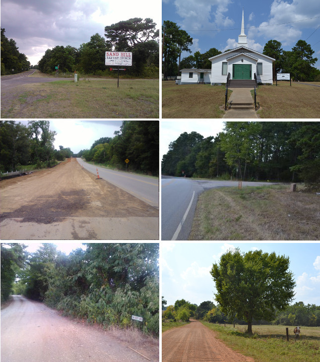
Middle (l to r): Highway 21 widening project at Melrose; Site of OSR Marker #12.
Bottom (l to r): Scott Lane (the expected OSR Marker #13 location); County Road 302.
SH 21 / Melrose / CR 302
Highway 21 follows the Old San Antonio Road very closely from OSR Marker #11 west of Chireno to the east side of Melrose. The countryside along the highway is typical for this part of the state: farms, pastures, gas fields, and undeveloped woodlands.
In the 1800s and early 1900s, the roads east of Nacogdoches were populated with numerous communities, such as Oak Ridge, Sand Hill, New Hope, and Melrose. Today, some these communities exist only as remnants in the form of the streets, businesses, and churches that were named after them.
Melrose, which is about 9 miles east of Nacogdoches, was founded around 1840 by Dr. Thomas Jefferson Johnson.2 He is said to have named it after Melrose Abbey in his native Scotland. The town grew to about 250 inhabitants by 1900. It began to decline after World War I; its post office closed in 1921. It has but a handful of churches and small stores today, and about 150 residents.
In 2013, a construction project was underway to widen Highway 21 beginning at FM 3276 in Melrose, for about four miles to FM 226.
On the west side of Melrose, Highway 21 intersects with County Road 302. OSR Marker #12 is at this location. Tracing Zively's route of the Old San Antonio Road between here and Nacogdoches is problematic. It is clear from looking at any old map of Nacogdoches County that prior to Highway 21's construction, County Road 302 - or "Upper Melrose Road" - was the main highway from Nacogdoches to San Augustine. Zively, however, drew a route well to the south of CR 302, and having a very different shape. Zively's route not only does not appear on any maps, but there are also no discernable clearings or other evidence of it, either on the ground or in satellite images. While Zively could conceivably have been following an older route that had already disappeared from all maps thirty years before his survey, it was his standard practice when he departed from a newer road to follow an older one to show the "road now used" on his sketch. He did not do that here, which implies that he thought he was following a current, well-known route. We will not go so far as to say that Zively's sketch of this area must be wrong, but we will say we have a hard time seeing how it can be right.
Right or wrong, Zively's route departs from Highway 21 at present-day FM 3276. It stays roughly parallel to Highway 21 until intersecting with it again approximately at Atascoso Creek. It then stays on Highway 21 to Scott Lane, which is the expected location of missing OSR Marker #13. At Scott Lane, Highway 21 turns west, while Zively's surveyed route continues northwest. Zively's route connects with County Road 302 near Nacogdoches, east of OSR Marker #14.
Page last updated: February 24, 2014
1He did, however, show the house occupied at the time by Flournoy's oldest son, Warren M. Flournoy. It was at the point east of Chireno where the old route and the newer Camino Arriba separated.
2Another Texan of the same name, a schoolteacher, came to Texas in 1844. That Johnson did not live in Nacogdoches County.
- Zively, V.N. - "Field Notes and Detail Map of the Kings Highway", 1916
- Carson, David - field notes observed and recorded in 2013
- Texas State Historical Association - The Handbook of Texas Online
- Stephen F. Austin University East Texas Research Center